


Expedition
Come with us to explore the beautiful southwest National Parks in Utah.
Our trip is fully equipped inside the comfort of an Rv, it will be 6 days, 5 nights touring magnificent terrain, beautiful landscaping at Bryce Canyon, Zions, Arches and Canyonlands National Parks.
Our meeting place will be at Salt Lake city Airport, this will be the place to start and end our expedition.
What’s included:
- Transfer from/to Salt Lake City Airport to the selected hotel
- Hotel accommodation for the first night prior to the event.
- 5 nights in a Recreational Vehicle (RV) Touring Utah National Parks,
- accommodation guaranteed inside the motor home,
- food and utensils (breakfast, snacks for lunch and dinner) during RV touring
- All camping fees,
- National Parks entrance fee
White water rafting (weather permitting ) and surcharges are included.
Trip does not include:
- Airfare to/from Salt Lake City UT,
- travel insurance,
- baggage fees,
- Personal gear, sleeping bag, linen,etc.
Price: $1100,00 PER PERSON
Itinerary
Day 1 – Bryce Canyon
Day 2 – Zions National Park
Day 3 – Moab
Day 4 - Colorado River White water rafting and Canyonlands National Park
Day 5 - Bonneville Salt Flats

Bryce canyon - Hoodoos (irregular columns of rock) exist on every continent, but here is the largest concentration found anywhere on Earth.
Red rocks, pink cliffs and the endless vista landscaping.
We will arrive at Bryce Canyon @ 1pm, e and hike the trails Wall street trail, Hike Queen's Garden/Navajo Loop Combination Difficulty: Moderate
Distance: 1.4 miles (2.2 km)
Elevation gain : 515 feet (157 m)
Average time : 1,2 hours
We will arrive at Bryce Canyon @ 1pm, e and hike the trails Wall street trail, Hike Queen's Garden/Navajo Loop Combination Difficulty: Moderate
Distance: 1.4 miles (2.2 km)
Elevation gain : 515 feet (157 m)
Average time : 1,2 hours

Zions National Park
We will hike the famous The Narrows
The hike, with walls a thousand feet tall and the river sometimes just twenty to thirty feet wide, is one of the most popular areas in Zion National Park. You most get your feet wet, and this trail is considerate one of the most beautiful hikes in the world.
Difficult: Moderate
Distance: 6.5 miles (10km)
Elevation gain: - none
Average time: 5-6 hours

Arches National Park
We will hike Delicate Arch trail, this is the Symbol of the state of Utah considerate one of the geological formation most famous in the world.
The light opening beneath the arch is 46 feet high and 32 feet wide, making it the largest free-standing arch in the park. It has had more than a few names in its history, from the colorful ("Cowboy's Chaps", "Old Maid's Bloomers") to the prosaic ("Salt Wash Arch"). The term "Delicate" first appeared in a January 1934 article about the Arches National Monument Scientific Expedition, which described it as "the most delicately chiseled arch in the entire area."
Difficulty: Moderate
Distance: 3 miles (4.8km)
Elevation gain: 480 ft – 146 m
Average time: 2-3 hours.

We will come down 7 miles at the Colorado River, from Fish Tower to Rocky Rapids, it will be 4 hours of fun rapids category II and III.
Calm waters on the first part of our journey provide relaxation and some time to learn and see the geology around the canyon. After calm water always come the storm, be ready to have some fun starting on Onion Creek rapids following several others rapids.
Afternoon we will hit our next destination - Canyolands National Park
Calm waters on the first part of our journey provide relaxation and some time to learn and see the geology around the canyon. After calm water always come the storm, be ready to have some fun starting on Onion Creek rapids following several others rapids.
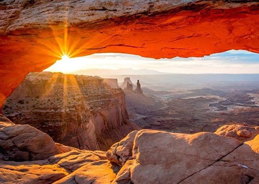
Perched at the edge of the mesa top, this 27-foot-long (8.3 m) arch frames views of the canyon far below and the La Sal Mountains in the distance.
Difficulty: easy
Distance: 1 mile (1.6km)
Elevation Gain: 56 ft – 17 m
Average time: 1 hour
Difficulty: easy
Distance: 1 mile (1.6km)
Elevation Gain: 56 ft – 17 m
Average time: 1 hour

Boneville Salt Flats
The Bonneville Salt Flats are one of Earth's most unique landforms. The salt flats are about 12 miles long and 5 miles wide and are comprised mostly of sodium chloride, or table salt. Located 120 miles west of Salt Lake City in Tooele County, Utah, the salt flats are a 30,000 acre expanse of hard, white salt crust on the western edge of the Great Salt Lake Basin in Utah.
The Bonneville Salt Flats are one of Earth's most unique landforms. The salt flats are about 12 miles long and 5 miles wide and are comprised mostly of sodium chloride, or table salt. Located 120 miles west of Salt Lake City in Tooele County, Utah, the salt flats are a 30,000 acre expanse of hard, white salt crust on the western edge of the Great Salt Lake Basin in Utah.
- Locale : Moab Utah
- Category : Photography
- Itinerário : Itinerary